Have you ever wondered if you know well the geography of our country?
If your answer is no, then we invite you to know some rivers in your next vacation. Costa Rica is truly a place blessed with wonderful landscapes full of impressive vegetation, exuberant flora and fauna, and much more … This beautiful country is ideal for the enjoyment and delight of all its visitors, especially those who like the forest and who enjoy spending recreation time in rivers. In this article, we will talk about some rivers that you can visit in this gem of the world biodiversity called Costa Rica.
Tres Ríos, Cartago
Due to the rustic charm and beauty of the small towns of Costa Rica, you will undoubtedly enjoy the small community of Tres Rios, in the province of Cartago. With its wide green views, Tres Ríos offers serenity and a quiet atmosphere that radiates tranquility to any visitor.
Come to appreciate the landscapes and be in love with the coffee, the people and the authentic Costa Rican experience.
Immerse yourself in nature
The town of Tres Ríos offers majestic and breathtaking views over the mountainous landscape and gently sloping hills, providing something not found anywhere else.
Its natural environment inspires visitors to meditate, in total serenity, and attracts the most adventurous to walk the steep trails and discover wonders among the abundant flora.
You can also visit 2 protected areas, established to conserve the wildlife of the mountain. The zones include the Tiribi River Protective Zone and the Cerro la Carpintera Protective Zone. Of the 2, Cerro Carpintera offers the most expansive and investment experience, with an amazing diversity of flora and fauna.
Multiple species of raccoons, parakeets, rabbits, and squirrels make this a great stop for anyone with a nuanced eye for the differentiation of species and a fascination for ecological study. For a more sporting adventure, you can also practice rappelling on 19 platforms -in 2 designated areas; Take a canopy tour, or walk for 30 minutes through the forest to experience the wildlife first-hand.
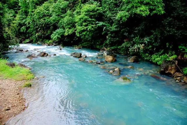
Celeste River, Alajuela
One of the most beautiful natural spectacles that you can admire is the Celeste River. The most characteristic feature of this river is that its waters change color and tonality. It is the result from the junction of the Quebrada Agria and Buena Vista rivers.
This body of water is located in the Canton of Guatuso, in a province called Alajuela, near the Tenorio Volcano National Park, which keeps the beautiful Celeste River in its surroundings.
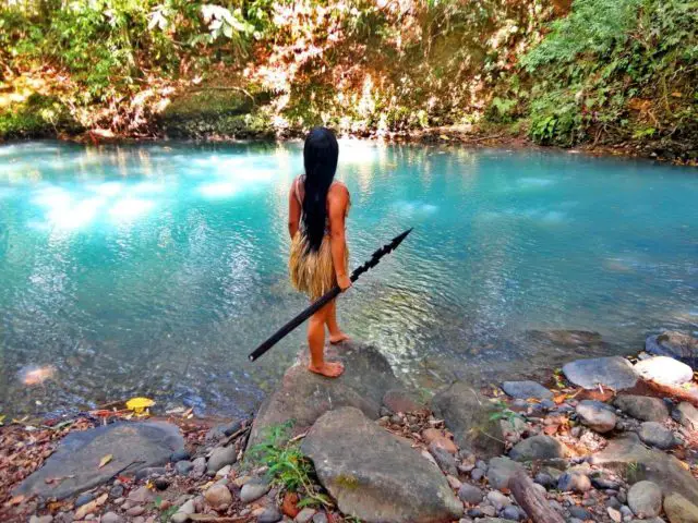
The main attraction of this river is its coloration, which is blue. In relation to this, many theories and legends have emerged trying to explain why it is that color.
Its climate is rainy for almost the entire year. As for the dry season, it is not very defined. For this reason, the location of Tenorio Volcano Park is described as very rainy and cold.
Motivated to this, it is normal that during the journey towards the Celeste River the climatic conditions are rainy during any time of the year.
How to get there?
For independent tourists, the best way to get there is by taking a bus in San José to Ciudad Quesada and, from there, take another bus to Guatuso, where upon arrival you will take a taxi to Río Celeste.
Another way to get there is from San José to La Fortuna de San Carlos and from there to U Pala arriving at the street that leads to Pilón de Bijagua. From this street to Rio Celeste it takes an hour and a half. You can also hire a private tour.
San José River, Sarapiquí, Heredia
This river also belongs to the Caribbean side of Costa Rica. As Limón is the wettest slope, therefore, it is also the most biodiverse and the one with the most impressive landscapes and rivers.
The San José River rises in the mountains of the Braulio Carrillo National Park and has an enormous amount of pools or optimal places to swim and fish.
The Sarapiquí River is located in the province of Heredia north of San José. This one is born in the skirts of the North of the Central Mountain range, in the old crater of the Poas Volcano, turned into a lagoon of cold and crystalline waters. It is a tributary of the San Juan River, a natural heritage of the country.
The Sarapiquí River area is located in one of the wettest regions of the country, influenced by the humid tropical climate of the Atlantic, with high fluvial precipitation throughout the year, with a drier season during February, March, and October. The average annual temperature is 25.3 ° C, with a maximum temperature of 30.0 ° C and a minimum of 20.2 ° C. The average annual rainfall is 3,777 millimeters.
Barbilla River, Matina, Limón
This incredible river of the Province of Limón rises in a row Matama, which is a ridge or spur that emerges from the Tala Manca mountain range, giving an incredible landscape to this rich and beautiful province.
Río Grande de Térraba, Puntarenas
The largest and longest river in Costa Rica is born on the Pacific slope of the Talamanca mountain range. It takes advantage of the topography that allows most of the rivers of southern Costa Rica to pour their waters directly into this great river, which, being so extensive (160 kilometers), has many places where it forms incredible pools and small ponds where it is possible to swim and fish.
Known as Diquis River, which in the Boruca language means “big water”. In parallel, the name Terraba refers to the indigenous community of the same name that lives on the banks.
Your main tributaries They irrigate an agricultural region dedicated to the cultivation of sugarcane, coffee, bananas and the raising of cattle.
It is the habitat of the American crocodile, while its riverbank at its mouth is home to numerous ducks and waders. Among many resident herons are the tip of the boot and the tiger heron. Other birds that can be observed are the stone curlew, the mangrove canary and the dwarf kingfisher.
You can enjoy tours along the river bank to appreciate crocodiles and lizards.
Pacuare River
It is one of the most visited in Costa Rica. Being part of the slope of the Atlantic, with a length of 133 kilometers, it is born on the hills Cuereci in the mountain range of Talamanca, to 3,000 meters on the level of the sea. It descends through the mountains to the plains of the Central Caribbean, in the province of Limón and empties into the Caribbean Sea, between Boca de Parismina and Apianó lagoon, near the Matina River. The Sequiares, Suru, Peje, and Piedras Blancas rivers are its main tributaries, among others.
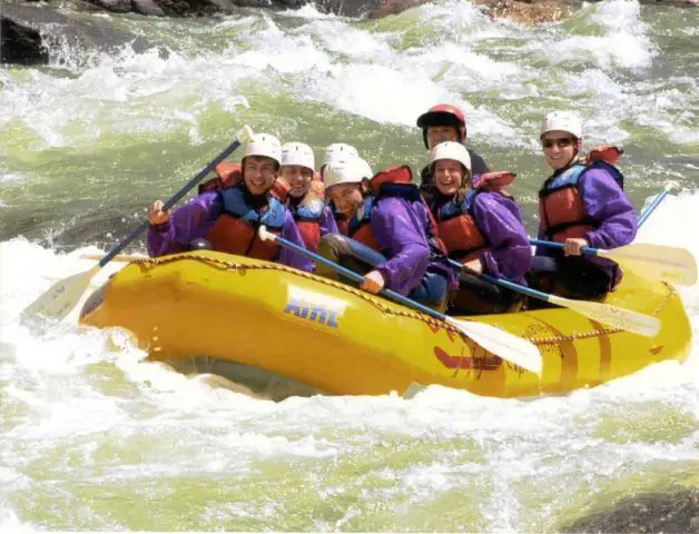
Due to the exuberance of the vegetation that surrounds it, and the numerous rapids that it forms during its descent towards the Caribbean plains -which are apt for extreme sports such as rafting-, Pacuare River is an important tourist attraction of Costa Rica. The Pacuare basin is protected by the Matina Pacuare Forest Reserve.
Wildlife
The rainforest and several micro-climates of Pacuare host an impressive selection of wildlife. Because most of the river canyon has not developed, visitors can observe a dense population of animals that are rarely seen in other parts of Costa Rica.
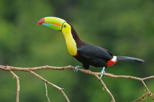
Some of the most difficult species to observe include river otters, jaguars and ocelots. The most common sightings are those of howler monkeys, capuchin monkeys, sloths, iguanas, coatis, and raccoons. Birdwatchers will be delighted with daily appearances of colorful birds, such as toucans, macaws, monkeys, herons, kingfishers, among others.
Sierpe River
It is born in the mountainous rows of the Golfo Dulce Forest Reserve, and its route never exceeds an altitude of 20 meters above sea level. For this reason, its course is slow, prone to cause floods, with the great contribution of sediments. In the vicinity of its source is the Sierpe lagoon, a small natural reservoir of 1.02 square kilometers of a “water mirror”.
It is navigable by small boats in several kilometers of final cause. Its mouth covers marshes, meanders and is part of a wide delta (called Delta Sierpe-Terraba or Diquis), which is located in Coronado Bay, where the small island Violin is formed.
Maritime traffic is quite common among locals and tourists. There is an abundant range of wildlife. The American crocodile, among several other species of reptiles, and exotic fish and birds can be seen in this area.
This area is part of the Terraba-Sierpe National Wetland, which has a great biological variety and an incalculable cultural heritage. It is represented by a mangrove forest ecosystem -the largest in the country-, which is periodically flooded by the action of the tides, and where there is an appropriate supply of sludge, very rich in organic matter.
