The Costa Rican Railway Institute is an autonomous institution in Costa Rica, responsible for the administration of the national railway system. It was created on September 19th, 1985 through the Republic Law 7001, having various reforms and providing greater economic resources than the previous institution, Railways of Costa Rica (FECOSA), to manage the railways and train transport of the country.
The Railroad of the Pacific becomes the Costa Rican Institute of Ports of the Pacific in 1972 under the administration of José Figueres Ferrer so that it was called Ferrocarriles de Costa Rica, S.A. (FECOSA) in 1977. In 1985 the Incofer was formally created and both railroads were put under its administration. In 1995 during the administration of José María Figueres Olsen, the Incofer is closed by Decree SCD-106-95 of June 28th, and its employees are dismissed. Its reopening occurs in the administration of Miguel Ángel Rodríguez Echeverría, again by Decree N° 035 of September 9th, 1998. Starting then with very limited cargo transport in the province of Limón.
In 2005 under the administration of President Abel Pacheco, regular passenger transport was reactivated along a section of road that includes Metropolis in Pavas to the Universidad Latina in San Pedro de Montes de Oca. Later in 2009, under the administration of Óscar Arias Sánchez, the train service between the capital and the city of Heredia was launched, with great success and acceptance because of the time saved for the users. Sometime later, in 2011 and 2013 the services to Belén and Cartago were reactivated.
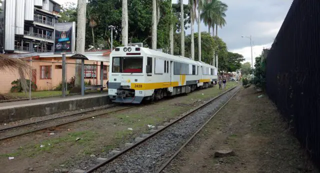
This option of interurban transportation has had great acceptance by its users, since it went from transporting 1,000 people per day, in 2005, to more than 20,000, nowadays, in its 4 routes currently put into service, provided with approximately 19 units. For this reason, it is used at rush hours in the morning, from approximately 6 a.m. to 7:30 a.m., and in the afternoon, from 5 p.m. to 7 p.m. In spite of the good capacity of these old units, they are not allowed to coarsen due to the high demand in much of the routes.
This service is currently operating 5:30 a.m. to 9:00 a.m., and 3:30 p.m. to 8:00 p.m.
Routes of interurban and cargo trains in Limón
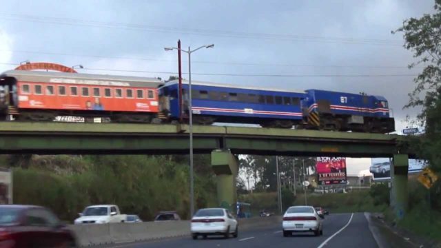
San Jose-Heredia-San José
San José is the capital of the Republic of Costa Rica and the capital of the province of the same name. Located in the center of the country, on the Inter-volcanic plateau called Central Valley, San José is the most important political, economic, and social center of the Costa Rican territory.
Heredia is a city in Costa Rica located about 10 Kilometers northwest of San José. It is the capital of the central canton and the province of the same name. The city of Las Flores is the coffee capital of Costa Rica, producing the Costa Rican Gold Bean.
Heredia becomes the center of the economic activity of the canton and the province itself. This, added to the growing trade of the city, has reduced the housing space. That is why it has some “satellite” districts such as Mercedes, Ulloa, and San Francisco. All this population, together, is to be around 118,470. Even the cantons of the province Barva, Santo Domingo, San Rafael, San Pablo, Flores, Belén, Santa Bárbara, and San Isidro serve as suburbs; forming the Metropolitan Area of Heredia.
San José-Metropoli III in Curridabat-Pavas
Pavas or Las Pavas is the 9th district of the San José canton. Pavas is the most populated district of Costa Rica (the district has a bigger population than 69 of the 81 cantons, a subnational entity of higher level) since according to the 2011 Census has 71,384 inhabitants and 19,735 homes in an area of 9.34 km2. The average altitude of the district is 1,044 meters above sea level, the lowest among the districts of San José.
Pavas has important urbanizations and industrial zones. The district can be seen from expensive and highly urbanized areas (Rohrmoser, for example), to problematic neighborhoods with high levels of poverty. Pavas or Las Pavas was part of the land donated by Father Manuel Antonio Chapuí to the citizens of San José. It began to be populated late in the 19th century, after national independence. Among its first buildings, highlights the construction of the church in honor of Santa Barbara. Pavas is designated school district in 1922. While the 20th century progressed, the area benefited from the main basic services. It used to have, for example, a police agency, a post office, and a pipe that was renovated in 1952.
San José-Belén-San José
Belén is the 7th canton of the province of Heredia, Costa Rica. It is part of the Great Metropolitan Area, where the residential area constitutes at least 25% of the surface of the canton. It was founded on June 6th, 1907. The economy of the canton of Belen is based on industry, commerce, and services. The new industries installed are technologies, hotels, manufacturing, trading, among others.
San José-Cartago
Cartago is located in the Guarco Valley, in the central region of Costa Rica. Geographically, it has an altitude of 1,435 meters above sea level. The city of Cartago was founded in 1563 by the Spanish conquistador Juan Vázquez de Coronado. Its original name was Santiago de Cartago since its parochial church was dedicated to Santiago Apostle, although that name only seems in some isolated documents of the time of the Spanish domination.
San José-Alajuela
Alajuela is a city in Costa Rica, about 20 kilometers west of the capital San José. Alajuela is the head of the canton (central), as well as being part of the Greater Metropolitan Area. The space that today occupies the Alajuela district has been inhabited for about 10,000 years. For the 16th century, the area was part of the Huetar Kingdom of the West, ruled by the cacique Garabito.
Juan de Cavallón y Arboleda was the 1st European to arrive in the region (1561) and built the Castillo de Garcimuñoz for Spanish settlers. King Garabito did not accept the Spanish invasion, beginning the indigenous resistance, which succeeded in expelling that Spanish conqueror from the Western Central Valley; later he fought against Juan Vázquez de Coronado, his successor.
San José-Paraíso
Paraíso is the 2nd canton of the province of Cartago (Costa Rica). It is located east of the Guarco Valley.
Its capital city of the same name and is located about 8 Kilometers southeast of the city of Cartago, so it is part of its metropolitan area. Ujarrás was what gave rise to what is now known as Paradise, because in 1832 the Head of State, José Rafael Gallegos, ordered the transfer of that population to the territory known as Llanos de Santa Lucía.
Paradise was one of the 1st places to be colonized when the Spaniards arrived. Even today, the colonial church of Orosi and the ruins of Ujarrás are preserved as a reminder of the Spanish colonization. It is also known as the place of the blue crab.
Transportation of banana in Matina
The Canton of Matina is the 5th in the province of Limón, Costa Rica, and was created by law 4344 in 1969. Its head is the city of Matina. But, although the head of the canton is the city of Matina, the town of Batán is also an important center of population and commerce.
The main income of the canton is provided by agriculture, especially banana production and to a lesser extent livestock. In the middle of the seventeenth century, during the colonial era, cacao farms were established in this area. Between 1682 and 1691, there were about 44 farmers who had approximately 92,700 cacao trees. This industry based on cocoa was of great importance to the colony.
Steel transport from Moín to Leesville in Guácimo
Guácimo is the 1st district of the canton of Guácimo in the province of Limón in Costa Rica. Its head is the city of Guácimo, located at an altitude of 114 meters above sea level and at a distance of 83 Kilometers west of the city of Limón. The town occupies an alluvial plain on the banks of the Guácimo River.
The district includes the neighborhoods of Africa, Cantarrana, Guayacán and the towns of Aguacate, Angelina, Bosque, Cabaña, Edén, El Tres, Rudín Station, Fox Hall, Guaira, Hogar, Parismina, San Luis, Selva.
Tourist transport in Limón and Siquirres
Puerto Limón or Limón is a city in Costa Rica, head of the canton and the province of the same name. It is located at a distance of 152 Kilometers east of San José, capital of the Republic, on the coast of the Caribbean Sea. Its port is the largest and most important for commercial uses of this Central American country. The canton was populated by indigenous tribes before the arrival of the Spaniards.
Tourist transport to Caldera
Caldera or Puerto Caldera is the largest and most important Costa Rican seaport for commercial uses on the Pacific coast of this Central American country.
It is located in the Caldera district of the corner of Esparza, in the province of Puntarenas. Its location covers the bay of the same name, at the entrance to the Gulf of Nicoya. The city of Puntarenas is 28 Kilometers northwest of this port, and Orotina is about 26 Kilometers to the east. From the colonial era, and until the beginning of the 20th century, Caldera has been the main port of the Costa Rican Pacific coast. Initially, there were loading and unloading operations in the bay, by means of boats.
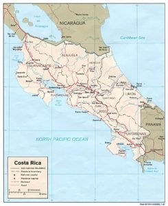
As we can see, Costa Rica has a railway system that covers a large part of the territory, along with a total distance of 72 kilometers, thus obtaining a great benefit for both merchants and common population, including the tourism sector. All of that makes a better standard of life all over the Costa Rican territory.
