Each city and each zone of Costa Rica has some characteristic that captivates and makes us curious beyond the simple sight of the beautiful landscapes.
Jaco, for example, is a city on the Pacific coast of Costa Rica, located to the southwest of San Jose, which contains a wealth of history and geography, which is why we recently had a pleasant conversation with the geographer of the University of Costa Rica and the Costa Rican Institute of Electricity (ICE), Jose Rivas.
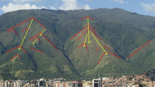
They are relatively recent geological faults, so their expression in the relief is easily visible, and in the photo, it appears to be a fault zone with less than five visible traces”, he calls this landform: triangular facets”.

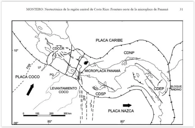
Rivas shared two maps with our team of journalists pattern: The first is from a study by Walter Montero, who is a geologist at the Central American School of Geology at the University of Costa Rica, called Neotectonics of the Central Region of Costa Rica: Frontier or this Panamanian microplate, which was published by the Geological Journal of Central America in 2001, considered valid by the geographer.

José explained, “In the map, you can observe that Costa Rica has fault zones, we are between two plates: the Caribbean plate and the Cocos plate, the black arrow indicates that the Cocos plate evaporates below the Caribbean plate, -there is a movement that makes the Caribbean plate go above the cocos plate, that is very important-“.
In this way, the symbology of the map includes the volcanic central-south central cordillera, so it may as well be neotectonic, as the text of the study says. Laneotectonics is the study of the movements and deformations of the present-day earth’s crust in the current geologic time measured in eons; “under this point of view where conditions of this type can be found, in the case of Quepos, also that area towards the rivers Tulín and the Turrubaritos river, there are studies that in the area there is this type of deformation associated with faults, so the important thing to note is that this type of geomorphology or this type of landform is very typical of this neotectonic activity, and in the photo, it looks like a fault face with five visible traces, and I put a picture of it where it is more characteristic, but it is not very characteristic of the country, just to show what it is,” he explained.
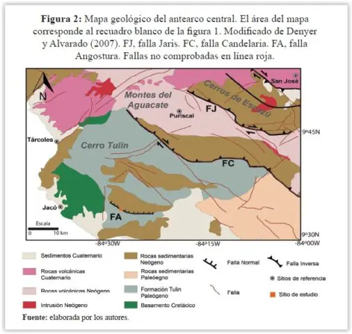
Now, about the second map presented by José Rivas, we can appreciate a geomorphic of the Tulín and Turrubaritos rivers to the deformation, the Angostura fault before the central arc of Costa Rica; it is about the morphology of the rivers that are very close to the area where Jacó is located.

The geographer Rivas said that for example, “what is in gray, the Tulín hill, are geological formations that have already been studied, then there will be sediments, volcanic rocks, intrusive or basements… this map helps to understand that geology is very new, but also very dynamic, and being so dynamic these types of formations usually happen”.
All this was known about the curiosity of the mountains to enter Jacó, but there is much more and it is about the name, where does the name “Jacó” come from, and how to say it correctly?
It turns out that Jacó is known as the head city of the Garabito canton, it is the first district as highlighted by the geographer Rivas.
The city that has beautiful beaches with an ideal swell for surfers, bathed by the Pacific Ocean, where the sun, gray sand, music, and gastronomy predominate is correctly called “Playa de Jacó” not Playa Jacó.
Perhaps many people hear Aco, Jaco, Jacó, and even Yaco… The name Jacó, in the absence of an official origin, comes from two meanings. Perhaps, the most widely accepted is that it comes from a linguistic derivation of the word “Aco”. The RAE defines it as: “American tree of the leguminous family, with strong wood and about 10 or 15 meters high (Lonchocarpus Punctatus, H. B. et Kunth)”. Lonchocarpus Kunth (Fabaceae, Millettieae), is a genus of shrubs and trees comprising about 180 neotropical species, except one, distributed on the west coast of Africa.
The tree of the Fabaceae family is very common in the Mexican and African tropics.
Rivas said, according to what is said or has been investigated, that the first settlers of the area, dating from the late nineteenth century and early twentieth century, mainly Panamanians from Chiriqui, observed in the mountain ranges trees similar to the “Aco”, these trees were taken as a reference to locate and extract gum and balsa trees – in the area of Garabito canton, there is a Chiclera row and a Balsal beach -, fundamental in the construction of houses and boats.
The name “Aco” had such repercussions in the Costa Rican cultural heritage that it was immortalized in a geodesic vertex – cartographic sheet 1:50000 Herradura-, which was embedded in the ground on the southern flank of the Chiclera row. This work was carried out by the surveyor and geodesist, Mr. Enio Carballo Gutiérrez (Puntarenas, November 3, 1929 – San José, July 5, 2000) of the National Geographic Institute (IGN) in conjunction with the Inter-American Geodetic Survey (IAGS), in 1957.
Currently, the area belongs to a foreign owner who uses the land as a lookout point, from which the city of Jacó and adjacent beaches can be majestically observed.
Another meaning of the name Jacó is that it comes from the word Jacob, the biblical name, “a variant that was used at the beginning but in the cartography it does not appear as such, then the reference to the tree called “Aco” is the most outstanding”.
More details about Jacó and the geographer José Rivas
Jacó -first district, head city, and beach- has an area of 141.37 km². To the district belong towns such as Agujitas, Buenos Aires, Cañablancal, Cerro Fresco, Herradura, Mona, Playa Hermosa, Playa Herradura, Pochotal, Puerto Escondido, Quebrada Amarilla, San Antonio, Turrubaritos and Tusubres.
By the way, Jacó stands out for its nightlife, diverse activities, and services.
José Rivas, a geographer from San Ignacio de Acosta, has been working at ICE for 19 years. Now, he is finishing a master’s degree and would like to teach geography at a university. One of his goals is to share knowledge.

“In Costa Rica, there is a very big difference in the educational system, because when in schools they teach social studies they are very scattered in the subject of geography with what is history, what happens is that, when I realized that as a geographer I began to contribute with people when they wrote incorrect things, -there are people who publish photos, but they place misspelled geographical references-. We have a National Geographic Institute, which is the governing body of geography in the country, but people do not use the information systems at hand, which are official, which leads to making mistakes in location, and geographic names for example, which makes many of the publications that have good audios, videos or images as such lose the essence of real and complete life”, he said.
We appreciate the contributions of José, to bring to you our loyal followers, content for knowledge, and greater admiration of the different areas of our country.
It is worth mentioning that the Costa Rican geographer always relies on important sources to provide quality information. You can follow him on his Facebook page: Geográfo José Rivas to know all the wonders he writes about Costa Rica.

