Guatemala’s La Aurora International Airport closed three air navigation routes this past Wednesday due to ash from the Pacaya and Fuego volcanoes, which maintain high activity, authorities reported.
The National Institute of Seismology, Volcanology, Meteorology and Hydrology (Insivumeh) said in a press release that the explosive activity of the last hours in the two volcanic cones generates the presence of fine ash particles in the departments of Guatemala, which includes the capital, and Sacatepéquez (west).
Volcanic activity might increase
According to the scientific entity, the trend of the activity of the two volcanoes is to be maintained or even to increase in the next few hours, affecting Guatemala City and operations at the La Aurora international airport.
The General Directorate of Civil Aeronautics (DGAC) declared a yellow alert (prevention) and announced the closure of three air navigation routes at its facilities due to ash. For its part, the National Coordinator for Disaster Reduction (Conred) recommended that the Ministry of Public Health and Social Assistance (MSPAS) activate the protocols for attending the population due to the presence of ash.
He also suggested that the Ministry of Environment and Natural Resources (MARN) monitor air quality in the regions affected by the activity of the Pacaya and Fuego volcanoes, which are the most active of the 32 that the Central American country has.
Communities to take precautionary measures
The civil protection authorities recommended to the community, municipal and departmental leaders of Guatemala and Sacatepéquez to identify the centers that could serve as shelters for their habilitation in case the activity of both volcanoes increases. According to Insivumeh, the ash fall is due to the fact that in the last hours the wind direction changed to the north, northwest and east of the country.
Very active volcanoes
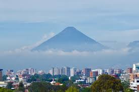
The 3,763-meter high Fuego volcano is located between the departments of Sacatepéquez, Escuintla and Chimaltenango, about 50 kilometers west of the capital, and is the most active in Central America. Its last major eruption was recorded on June 3, 2018, when the Fuego volcano took the lives of 431 people. While the Pacaya volcano is located in the municipality of San Vicente Pacaya, about 49 kilometers south of the Guatemalan capital, in the department of Escuintla.