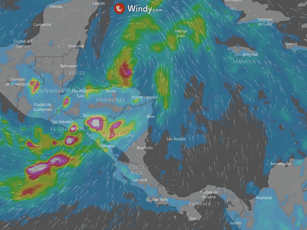
Tropical Wave 50 is slowly approaching Costa Rica with a high probability of becoming a depression. The National Meteorological Institute (IMN) reported on the afternoon of October 31st that the atmospheric disturbance is located between Haiti and the department of La Guajira, Colombia, and is advancing at about 24 kilometers per hour (km / h) towards the Caribbean of Central America.
Around 12:45 p.m. the wave had a more than 90% chance of becoming a cyclone. However, about five minutes later, the National Hurricane Center of the United States (NHC, for its acronym in English) – the official organ of the region – indicated that those probabilities had risen to 100%. Specialists say that it is imminent for the entity to call the weather disturbance a tropical depression.
Meteorologists explain that the first indirect effects of the phenomenon that will be positioned in the Caribbean of the isthmus begin to be perceived this November 1st; although the approximate time in which these will begin to appear is still uncertain, due to the remoteness that the disturbance still has.
The risk that the arrival of the cyclone represents for the country led the National Emergency Commission (CNE) to establish a yellow alert in the Central Valley, the Pacific, and the North Zone, as well as a green alert in the Caribbean. Significant rainfall is forecast for the first three regions in the South and Central Pacific.
The Meteorological Institute predicts downpours with thunderstorms during the afternoon and night; the strongest in the Pacific and the North Zone. Rains of variable intensity and isolated storms are expected in the Central Valley.
The President of the Emergency Commission, Alexander Solís, stressed on October 30th that the alerts have been in force since then and did not rule out that the levels will rise in the coming days.
“The yellow alert condition implies preparation. We are already mobilizing our SAR teams to different regions. In the afternoon we will make a call to the municipal emergency committees so that they carry out their alert sessions to prepare and reinforce the activities, prepare the shelters and identify areas with greater vulnerability,” explained Solís.
The official went on to call on the population to be cautious due to the saturation levels that the soils present in the country, as well as to increase the monitoring and surveillance of areas near mountains, rivers, and streams. For this reason, the institution calls for prevention, monitoring, and constant vigilance in those areas near mountains, rivers, or streams.
In case of rain
The president of the Emergency Commission, Alexander Solís, highlighted among the precautions that citizens should take when faced with rainfall:
– Stay informed and abide by messages disseminated by official entities at the national, regional, and municipal levels.
– Extreme care in mountainous parts of the entire country.
– Drive with caution due to rainy or foggy conditions on the main roads of the country.
– Be attentive to possible electrical storms. – Maintain the distancing measures and restrictions issued by the Ministry of Health in the situation of the national state of emergency due to the novel Coronavirus

