There are several sayings about things and small places, there are even people who are interested in the broad, that is, in the size of everything, and others who are more oriented by what they contain.
There are well-known sayings such as, for example, “valuable things take up little space” and “good perfume is sold in a small bottle”, you may wonder what we mean by these phrases and the issue of size. It turns out that much has been written about the surface areas occupied by the various nations of the world and that Costa Rica is among the smallest countries.

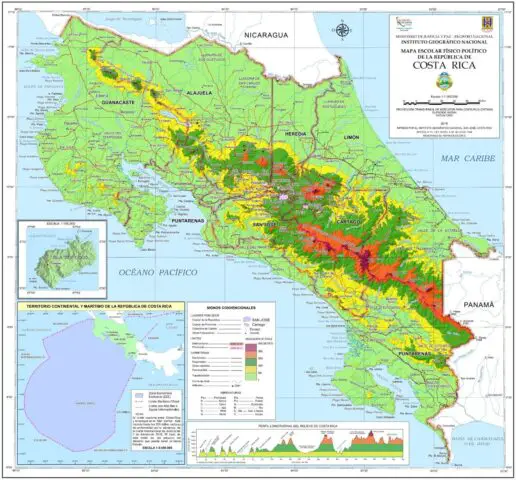
Costa Rica is a small Central American country that has an area of 51,179 square kilometers, reviewing the list of countries and dependent territories by area, we find almost 200 and that Costa Rica is ranked 126th, above Belgium, Haiti, Dominican Republic, Puerto Rico, El Salvador, Luxembourg, Switzerland, among others.
Yes, the Central American country its surface may be small, but undoubtedly it has too much to offer to its inhabitants and tourists, so much so that, in the past year 2023, Costa Rica obtained the best figures regarding the visits of tourists, the highest in all history during November; the visitors during the whole year (from January to December) were 2,190,055, according to data from the Ministry of Tourism.

The nation of the ¡Pura Vida! is known for being to the east by the Atlantic Ocean and to the west by the Pacific Ocean. It has 5.26 million inhabitants, as of last year the figure is known through the National Institute of Statistics and Census of Costa Rica (INEC).
Costa Rica occupies the narrow strip of mountainous and volcanic land that separates Nicaragua from Panama. It is one of the seven nations that make up Central America, the bridge that connects Mexico (in North America) and Colombia (in South America), and encompasses the isthmus of Panama.
Is Costa Rica really small?
The Costa Rican geographer, José Rivas, published in his social networks, a work called “Costa Rica: Limits, Surfaces and Extreme Points” that, thanks to the process of updating cartographic instruments, has allowed a more accurate measurement of the extension of the national territories.
Rivas, also informs us that, the so-called “Contracting for the taking of images and production of orthoimages and digital cartography of the entire National Territory”, is carried out by the National Registry through the Real Estate Registry and with the technical accompaniment of the National Geographic Institute (IGN) between the years 2014 and 2018, the objective of having a country-wide coverage of approximately 99% of its continental area was achieved.
This recent project generated, a sufficiently complete cartographic base of the national territory and therefore allowed updating the measurement of both the continental and insular area of Costa Rica, using modern tools of equipment and specialized Geographic Information Systems (GIS) programs.
The national territory -emerged lands- of Costa Rica turned out to be 85.63 square kilometers larger than previously known.
This, of course, does not mean that the territory has grown or that new islands have emerged in the national maritime area. It is, rather, an update in the calculation used to measure the Costa Rican continental and insular areas by that agency, attached to the National Registry.

Since 2013, specialists began to take new shots of the territory, as well as to produce orthoimages and digital cartography that allowed them to obtain the result. In this process, they were able to capture aerial shots of about 99% of the national territory, continental and insular (islands, islets, and emerged rocks).
In more detail…
It turns out that Costa Rica has a Continental Surface of 51,085.63 square kilometers, an Insular Surface of 94.29 square kilometers, a Total Terrestrial Area of 51,179.92 square kilometers, and a Total Maritime Area of 543,794.91 square kilometers (plus the Exclusive Economic Zone – EEZ – Caribbean Sea)Did you know that?
Therefore, the country is even more wonderful for its provinces, cantons, and districts, the Costa Rican geographer José Rivas specified, the most extensive and the smallest:
Largest province: Puntarenas11,298.51 square kilometers.
Smallest province: Heredia2,663.3 square kilometers.
Largest canton: San Carlos, Alajuela3,352.13 square kilometers.
Smallest county: Flores, Heredia6.75 square kilometers.
Largest district: Telire, Talamanca2,208.3 square kilometers.
Smallest district: San Francisco, Goicoechea0.58 square kilometers.
In the Caribbean Sea, despite the definition of the limits with the Republic of Nicaragua, by the Inter-American Court of Justice (ICJ, hereinafter) and the historical limit with the Republic of Panama, which dates from 1980, it cannot be mentioned that there is a definitive EEZ.
According to the rulings of the ICJ, in 2012, for the maritime dispute between Nicaragua and Colombia, and in 2018, between Costa Rica and Nicaragua, these leave without effect the limit established between Costa Rica and Colombia in 1977. Therefore, to close the limits of the EEZ in the Caribbean, it is necessary to enter into a new negotiation with the Republic of Panama.
However, according to data provided by the Geomatics and Topography and Territorial Observation Departments of the IGN, in the case of the Caribbean Sea, the approximate previous data when Costa Rica had an unratified boundary with Colombia and a unilateral boundary line drawn by Costa Rica, which represented its maritime boundary with Nicaragua was approximately: 26,193.53 square kilometers. “This number was the one used before the ICJ rulings between Costa Rica and Nicaragua and between Nicaragua and Colombia,” said Rivas.
Thus, as a result of the sum of the continental, insular, and maritime areas in both the Pacific Ocean and the Caribbean Sea, we obtain a total of 621,168.36 square kilometers. With this surface we are comparable to countries such as the Central African Republic and South Sudan, surpassing nations such as Spain, Cameroon, and Sweden, for example.
In his work, the Costa Rican geographer, added concerning the sum of the continental, insular, and maritime areas in the Pacific Ocean and the Caribbean Sea, that with the clarification of the negotiations with Panama, this figure may increase. “It is up to the Ministry of Foreign Affairs to reactivate the talks with Panama. However, this depends on the willingness of the Panamanian counterpart to sit at the negotiating table”.
World Data: The land mass differs from the countries with greater maritime sovereignty, since some of the largest states in the world are land powers with little geographical projection to the sea, such as Kazakhstan, which is the largest country without direct access to the open sea, or China, which has built a gigantic economic and diplomatic strategy to dominate maritime trade, but is surrounded by island chains under another flag.
The largest and the smallest
Russia is the country with the largest area, its surface is 510,072,000 square kilometers, of course, it occupies the first place in the list worldwide, followed by Canada, the United States, China, Brazil, and Australia.
Canada, the United States, and China have a similar extension, between 9 million square kilometers, but their population is not. Canada has about 38 million inhabitants, the United States about 331 million, and China 1,412 million, almost ten times more than Russia, but size is not always everything, which is why we highlighted it at the beginning.
Other large but sparsely populated countries that occupy large arctic expanses are Greenland and the United States (Alaska); jungle countries such as Brazil, the Democratic Republic of Congo, or Indonesia; or desert countries such as Australia, Argentina, Kazakhstan, Saudi Arabia, Sudan, Libya, Mongolia, Chad, Niger or Mali.
Finally, Vatican City, with 0.44 square kilometers, is the “smallest landlocked country in the world”, according to the word list.

